About the 3D-ABC Project
The 3D-ABC project develops advanced AI tools to map global above and below terrestrial ground carbon stocks with consistency and high spatial resolution. By combining multiple data sources, from satellites to field observations, it aims to reduce uncertainties in carbon accounting and to better capture the dynamics of terrestrial ecosystems. This supports scientific understanding and informs policy decisions related to climate change and land management.
«Recent advances in Foundation Models (FMs) are transforming AI, enabling remarkable generalization and zeroshot learning capabilities. The Helmholtz Foundation Model Initiative (HFMI) is developing the 3D Above and Below Ground Carbon Stocks foundation model (3D-ABC FM) [...]. The 3D-ABC FM aims to provide a seamless understanding of vegetation and soil carbon distribution by integrating multimodal datasets and addressing complex challenges such as multi-dimensionality and multi-resolution in FMs. 3D-ABC FM offers a transformative approach monitoring terrestrial carbon and advancing climate science.»
Source: Grosse et al. (submitted)
Our Approach
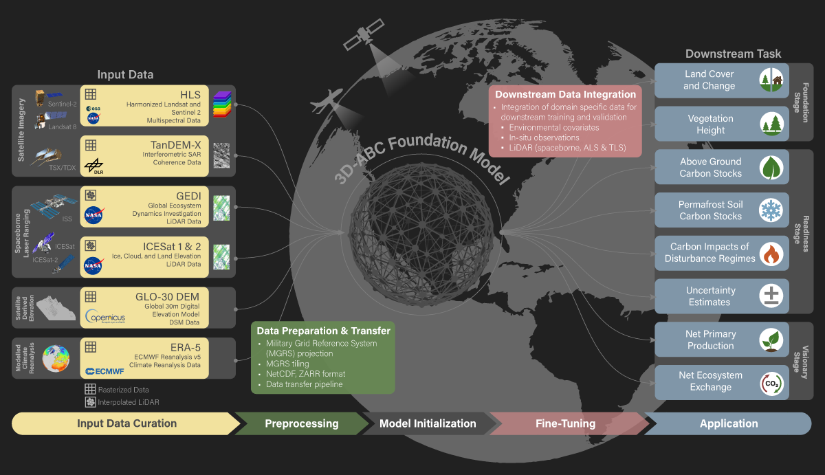
3D-ABC applies a staged approach to handle the complexity of terrestrial carbon estimation. It begins with assembling and processing large volumes of remote sensing data, lidar observations, radar data, climate reanalysis products, and in-situ measurements. After extensive preprocessing, the model undergoes self-supervised training to learn general features across these diverse datasets. Fine-tuning with labeled data from various regions and tasks allows the model to adapt to specific carbon estimation objectives. This methodology integrates heterogeneous data types into a unified framework, while maintaining flexibility to generalize across ecosystems, and supported by international data sharing and collaboration.
Overview of the 3D-ABC Foundation Model
The 3D-ABC Foundation Model uses a multimodal AI architecture trained directly on diverse inputs, such as InSAR coherence, full-waveform lidar, multispectral imagery, climate reanalysis data, and field measurements. These modalities are jointly pretrained to capture both local and regional carbon-relevant patterns. Fine-tuning on labeled datasets allows the model to meet specific task requirements across different ecosystems. This design enables the model to adapt efficiently to multiple carbon monitoring applications without retraining for each task.
High-Performance Computing (HPC)
High-performance computing is central to managing the scale and complexity of 3D-ABC. Processing the diverse, high-volume input data and training sophisticated models requires sustained access to advanced computational infrastructure, including early deployment on the JUPITER exascale system. HPC enables the development, optimization, and validation of models at the global scale, ensuring robustness and performance across multiple domains.
Carbon Stock Mapping
Accurately quantifying carbon stocks requires reliable estimates of both above-ground biomass and below-ground soil carbon. 3D-ABC integrates structural, spectral, and environmental data to generate consistent estimates of ecosystem carbon stocks while addressing uncertainties arising from data gaps and spatial heterogeneity. This integrated approach supports improved carbon accounting across biomes and climate zones.
The Amazon Region
Click to pause or resume. | Credit: Johannes Thomas Markus Wilk (GFZ)
The Amazon stores a significant fraction of global terrestrial carbon, making it critical for climate regulation and biodiversity. 3D-ABC combines multiple data sources to improve biomass estimates in this structurally complex region, using lidar, radar, optical imagery, and extensive airborne validation. The model captures forest structure and biomass patterns, supporting assessments of carbon storage and its vulnerability to deforestation, degradation, and climate-driven changes.
The Arctic-Boreal Region
Click to pause or resume. | Credit: Stefan Kruse and Guido Grosse
Permafrost soils in the Arctic-Boreal region store massive amounts of carbon, accumulated over thousands of years as cold, wet conditions slowed decomposition. Thawing permafrost exposes this carbon to microbial decay, releasing greenhouse gases and amplifying climate change. The 3D-ABC model addresses permafrost carbon by integrating diverse data to map soil carbon stocks across highly variable Arctic-Boreal landscapes. By capturing spatial heterogeneity and thaw dynamics, it improves estimates of vulnerable carbon pools critical for climate feedback projections.