News from the 3D-ABC project
3D-ABC at at the EUSAR conference in Baden-Baden
by Megan Udy

Members of the 3D-ABC team from DLR recently participated in the 16th European Conference on Synthetic Aperture Radar (EUSAR) from June 8-11 in Baden-Baden, Germany. Megan Udy presented a poster that provided an overview and status update on the project, with a focus on the processing status of the TanDEM-X datasets that DLR are contributing to the project.
Although it was a SAR focussed conference there were multiple sessions and other posters on foundation models, exploring how SAR integration into foundation models can be improved and applied to a range of downstream tasks. The poster session provided good discussions with other participants also working on foundation models that include different SAR datasets.
3D-ABC at Helmholtz AI Conference 2026 “AI for Science”
by Audita Widya Astuti

From June 8–11, 2026, HZDR’s 3D-ABC team took part in the Helmholtz AI Conference (HAICON), held in Munich, Germany. Audita Widya Astuti presented the self-supervised waveform-token pretraining strategy, which transforms sparse Global Ecosystem Dynamic Investigation (GEDI) Lidar waveforms into reusable embeddings for cross-modal fusion with optical imagery Harmonised Landsat Sentinel (HLS). As part of the 3D-ABC Foundation Model project, this work aims to estimate canopy height and above-ground biomass density (AGBD) estimation for global carbon stock mapping using these two modalities.
The poster presentation session generated interest among the participants, with discussions among Helmholtz members focused on the implementation of a Bidirectional Encoder Image Transformer (BEiT) for pretraining and a teacher-student knowledge distillation approach for densification tasks. Audience members were especially curious about carbon stock mapping pipeline and how this approach addresses these challenges.
Introducing icesat2DB: A Scalable Framework for ICESat-2 LiDAR Data Analysis
by Simon Besnard, Felix Dombrowski, Mikhail Urbazaev and Amelia Holcomb
The 3D-ABC project has openly released icesat2DB (https://pypi.org/project/icesat2db), a Python package designed to address current challenges related to the complexity and scalability of working with raw NASA ICESat-2 spaceborne lidar data. Built on gediDB, icesat2DB enables efficient spatial and temporal subsetting, supports parallel processing, and integrates seamlessly with Python’s geospatial data ecosystem.
The tool provides access to publicly available global ICESat-2 data, eliminating the need for local downloads, with complete documentation available online (https://icesat2db.readthedocs.io). By incorporating ICESat-2 data, icesat2DB extends vegetation structure measurements into boreal forests, where NASA GEDI does not collect data, while also increasing sampling density in regions covered by GEDI observations. This makes icesat2DB a valuable extension for large-scale vegetation structure analysis.
3D-ABC Project Meeting Brings Partners Together in Potsdam
by Tillmann Lübker

Over two days, a group of twenty participants met at AWI in Potsdam (and online) to discuss the next steps for the 3D-ABC project. Presentations from all partner centres (AWI, DLR, FZJ, GFZ, HZDR, and UFZ), along with in-depth discussions on upcoming deliverables and downstream tasks, quickly filled the agenda.
An open discussion forum at the end of the first day provided an opportunity to exchange ideas on a wide range of topics related to Earth observation foundation models, the project itself, and any related matters. Following a short walk on Telegrafenberg, which included a demonstration of instruments installed by GFZ, the day concluded in the pleasant atmosphere of a local restaurant, where discussions continued in a more relaxed setting.
On the second day, updates from consortium partners and planning of upcoming events brought the meeting to a close. Once again, it became clear that meeting in person is key to making good progress – and that, as always, time is all too short.
3D-ABC at the ESA PolInSAR & Biomass workshop 2026 in Ljubljana, Slovenia
by Megan Udy
")
Members of the 3D-ABC team from DLR recently participated in the 12th International PolInSAR & Biomass workshop at the University of Ljubljana, Slovenia, in January 2026. Megan Udy presented a poster that provided an overview of the project, including the project phases, the datasets involved, the AI and computing infrastructure, as well as the current status of the downstream tasks.
Despite it being a smaller workshop there was keen interest and discussion about the project with questions on the foundation model approach and how we are combining our large and diverse datasets.
This workshop provided the opportunity to present the project to audiences who otherwise may not have been aware of it and who want to know more about the foundation model approach to Earth observation.
3D-ABC Fall Consortium Meeting in Dresden
by Tillmann Lübker

The fourth in-person meeting of the 3D-ABC consortium took place in Dresden on 11 and 12 November. Partners from AWI, GFZ, UFZ, FZJ, HZDR and DLR gathered at the Open Science Lab to share updates and discuss the latest project developments. A short walk through Dresden’s Old Town and a joint dinner provided an opportunity to take a break from the meeting room and strengthen connections within our diverse team.
During the two-day meeting, we discussed developments in the eight downstream tasks, advances in 3D data processing, and current plans for data storage, publication and upcoming conferences. Conversations about future directions and potential new activities rounded off a programme full of information, ideas, and lively discussion.
3D-ABC at IGARSS 2025 in Brisbane, Australia
by Gunjan Joshi and Josh Hashemi

At IGARSS 2025 in Brisbane, Australia, the 3D-ABC team shared its latest progress and project overview on carbon stock mapping using foundation models. Gunjan Joshi presented the project overview to a full audience, introducing the foundation model at the core of the approach and outlining methods for integrating diverse Earth observation data. The session prompted thoughtful discussion and valuable feedback from the international remote sensing community, with strong interest in the foundation model approach to Earth observation.
Josh Hashemi presented a downstream task of 3D-ABC in the permafrost session, demonstrating the breadth of applications the 3D-ABC framework can support. His presentation highlighted how 3D-ABC can be used to estimate permafrost carbon stocks in vulnerable northern ecosystems, underscoring the potential of 3D-ABC and the importance of methods for quantifying carbon pools and in diverse regions with sparse in-situ data.
Together, the presentations emphasized both the methodological advances and the practical relevance of 3D-ABC. The strong engagement at IGARSS reflects the growing momentum in the community to explore and operationalize geospatial foundation models.
See the Publications section for more information.
Presenting Carbon Mapping Research at Major Helmholtz Conferences
by Gunjan Joshi

The 3D-ABC team had the opportunity to present intermediate project results at two key events in June 2025:
Helmholtz AI Conference 2025, held in Karlsruhe from June 3 to 5
Helmholtz Imaging Annual Conference 2025, held in Potsdam from June 25 to 27
At both conferences, we introduced our approach to large-scale carbon stock mapping using foundation models. We focused on integrating diverse Earth observation modalities, addressing the challenges of building representative training datasets, and sharing early model selection results from pilot regions.
These events provided an excellent platform to connect with the broader research community. We were encouraged by the strong interest in multimodal geospatial AI and appreciated the thoughtful feedback we received. Discussions in both formal sessions and informal settings offered valuable perspectives and raised important questions for the next phase of the project.
See the Publications section for more information.
Multimodal AI for Earth Observation: Highlights from the AI Lab Seminar
by Gunjan Joshi and Aldino Rizaldy
As part of the AI Lab Seminar series, Gunjan Joshi and Aldino Rizaldy delivered a two-session talk focused on the 3D-ABC project in the second week of July 2025. The first session, presented by Gunjan, introduced the design of the 4M model (Massively Multimodal Masked Modeling), a framework for learning from diverse data modalities. Building on this foundation, Aldino presented a concrete application: carbon stock monitoring using multimodal Earth observation data. He introduced the 3D-ABC project and its use of the 4M framework to fuse diverse datasets – including optical, radar, LiDAR, and climate data – into a unified model. He also discussed the design of specialized tokenizers for handling different data types and shared early results showing how self-supervised learning on 3D forest point clouds can improve performance in data-scarce scenarios.
Slides are available from hifis.net:
Gunjan Joshi: Introduction to Training Foundational Models with 4M. PDF
Aldino Rizaldy: Towards a Foundation Model for Global Terrestrial 3D Above and Below Ground Carbon Stock Mapping (3D-ABC). PDF
 and Aldino Rizaldy (right) presenting 3D-ABC work.")
Discussing the 3D-ABC Foundation Model at Conferences in Austria and Italy
by Tillmann Lübker, Samy Hashim, and Guido Grosse
[May 2025] Despite still being in its foundational stage, the 3D-ABC Foundation Model has made significant progress. Accordingly, members of the 3D-ABC team started presenting and discussing first project details at international conferences and workshops. In April and May, there was the opportunity to attend the large EGU conference and an ESA-NASA workshop on Foundation Models in Earth Observation.
In late April this year, almost 19,000 earth scientists found their way to Vienna, Austria, for the annual general assembly of the European Geosciences Union (EGU). The program made clear that there is growing interest in multimodal approaches for geospatial analytics as well as in more refined estimates of global carbon stocks. On early Monday morning, the project’s lead PI provided an overview on the 3D-ABC Foundation Model in an oral session dedicated to recent advancements in the development of foundation models. Regardless of the early morning timing, the session room was packed with listeners who even lined up at the edges of the room, confirming the very high interest in Foundation Models. Throughout the week, there were various opportunities to network with other projects and to discuss approaches.
In the second week of May, 3D-ABC team members from FJZ attended and presented 3D-ABC at the ESA-NASA International Workshop on AI Foundation Models for Earth Observation at ESA in Frascati, Italy. The workshop brought together researchers from across the globe to discuss how large AI models can be applied to satellite data to address pressing Earth science challenges – from deforestation and land use change to long-term climate monitoring. The workshop was a great opportunity to connect with researchers from both academia and space agencies and to see how open collaboration is shaping the future of geospatial AI. One key takeaway was how rapidly the field is moving toward open, reusable models and datasets, which aligns well with our project goals. It was particularly motivating to engage with others working at the intersection of AI and the space industry.
With their presentations at conferences and workshops, the 3D-ABC team reaches out to the broader international science community to share their latest research and foster collaborative opportunities. Before summer ends, you can catch up with team members at the Helmholtz AI Conference in Karlsruhe (3-5 June), the Helmholtz Imaging Conference in Potsdam (25-27 June), the ESA Living Planet Symposium in Vienna, Austria (23-27 June), and the IEEE International Geoscience and Remote Sensing Symposium (IGARSS) in Brisbane, Australia (3-8 August).
See the Publications section for more information.
Introducing gediDB: A Scalable Framework for GEDI LiDAR Data Analysis
by Simon Besnard (GFZ Potsdam), Felix Dombrowski and Amelia Holcomb
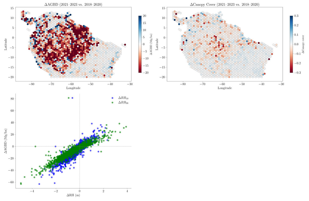
[May 2025] The Global Ecosystem Dynamics Investigation (GEDI) mission provides unprecedented LiDAR measurements of forest structure globally, offering new opportunities to study forest dynamics, carbon cycling, and ecosystem change. However, working with GEDI data is challenging due to the complexity of its raw formats and the scale of data involved. GEDI provides key input data on the 3D structure of global vegetation in the 3D-ABC Foundation Model project, which aims at using multi-modal Earth Observation, elevation, and climate data in a new foundation model to capture and track the stocks and dynamics of global vegetation and soils.
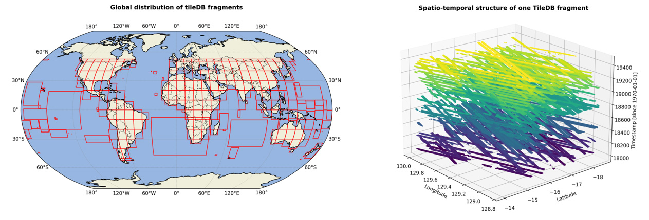
As part of the 3D-ABC project within the Helmholtz Foundation Model Initiative, the gediDB (https://pypi.org/project/gedidb/) has just been openly released by GFZ Potsdam. It is a Python package that addresses these challenges by offering a scalable, high-performance solution for accessing, querying, and analysing GEDI Level 2A, 2B, 4A, and 4C products. Built on TileDB, gediDB enables efficient spatial and temporal subsetting, supports parallel processing, and integrates seamlessly with Python’s geospatial data ecosystem (e.g., xarray, geopandas). The tool offers a publicly accessible global GEDI database (Fig. 1), eliminating the need for local downloads, and complete documentation is available online at https://gedidb.readthedocs.io.
Within 3D-ABC, gediDB plays a key role in building scalable software infrastructure for rapidly extracting large subsets of GEDI data for tasks such as analysing biomass and canopy cover dynamics, retrieving vertical canopy structure metrics (e.g., RH₅₀, RH₉₈), and performing spatiotemporal aggregation. By providing efficient access to global GEDI LiDAR data, gediDB facilitates ingesting vertical structure information into geospatial foundation models aimed at quantifying terrestrial carbon stocks. Fig. 2 illustrates how these capabilities enable regional-scale assessments of forest change and structure–biomass relationships.